

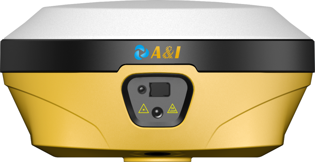
Land surveying often requires coordinates precise enough to establish control points, define boundaries, set out construction positions, or verify existing features. Basic GNSS positioning can provide useful location information, but many professional surveying tasks demand a much higher level of positional consistency. That is why surveyors use specialized satellite positioning equipment rather than relying on standard navigation receivers.
A Geodetic GNSS Receiver is designed for measurement workflows that make use of precise satellite observations, including carrier-phase measurements and correction services. Its value comes not from simply receiving more satellite signals, but from supporting the complete process needed to convert those observations into reliable survey coordinates.
Why Meter-Level GNSS Positioning Falls Short in Land Surveying?
A general GNSS receiver can determine where a point is located, but the resulting position may not be sufficiently precise for professional surveying. Singapore Land Authority guidance, for example, distinguishes standalone GNSS positioning from RTK, with standalone positioning generally operating at meter-level accuracy while RTK can achieve centimeter-level results under suitable conditions.
That difference becomes critical when two nearby points must be distinguished accurately. Property boundaries, engineering control points, road alignments, and construction set-out positions can require much tighter positional control than ordinary navigation applications.
Surveying also demands repeatability. A point measured today may need to be revisited later and produce a consistent result within the project’s specified tolerance. Consequently, equipment must work as part of a defined measurement and coordinate-control procedure rather than simply displaying a latitude and longitude.
What Makes Carrier-Phase GNSS Different for Survey Work?
The major technical distinction is the use of carrier-phase observations. GNSS receivers can work with satellite signals at the carrier-wave level, providing measurement information that is much more precise than relying only on conventional code-based positioning.
A survey-grade receiver can use these observations together with correction information to determine a highly precise relative position. RICS guidance on GNSS in land surveying identifies carrier-phase techniques and differential positioning as important foundations of high-accuracy surveying workflows.
Multi-constellation and multi-frequency reception can further strengthen the observation environment by providing access to signals from different satellite systems and frequencies. The exact performance still depends on satellite visibility, atmospheric conditions, multipath, correction quality, and measurement procedures, so receiver specifications should never be treated as a guarantee of field accuracy by themselves.
Why RTK Turns Satellite Measurements Into Field-Ready Coordinates?
RTK is important because it provides a practical way to obtain corrected positioning in the field. A reference station with a known position supplies correction information, while the rover receiver combines that information with its own satellite observations.
The result is a relative positioning solution that can reach centimeter-level accuracy when the necessary conditions are satisfied. Singapore’s SiReNT documentation describes RTK as a real-time technique capable of centimeter accuracy and explains the role of reference stations and correction information in the process.
An RTK receiver therefore does more than calculate a raw satellite position. It becomes part of a field measurement workflow in which corrections, carrier-phase observations, ambiguity resolution, and coordinate computation work together.
Network RTK can extend this concept by providing correction data from a network of reference stations. Such services can reduce the need for a survey crew to establish its own local base station, depending on project requirements and service availability.
Why Survey Accuracy Depends on More Than the Receiver?
Even a sophisticated receiver cannot eliminate every source of positioning error. Satellite geometry, atmospheric effects, signal obstruction, multipath, antenna setup, correction latency, initialization, and field procedures can all influence the final coordinate.
RICS recommends that survey specifications define the required accuracy, coordinate reference system, observation procedures, equipment, quality control, and processing methods. This demonstrates why survey-grade positioning should be treated as a complete measurement workflow rather than an equipment specification alone.
Archimedes Innovation’s AL16 is identified within its GNSS portfolio as a Laser RTK product. Its published documentation also describes functions related to point collection, stakeout, calibration, antenna configuration, and coordinate transformation, linking the receiver to practical field-survey operations.
For survey teams, this broader perspective matters. The equipment must produce usable observations under the actual conditions of the project, while the field workflow must provide sufficient quality control to identify unreliable measurements before they enter the final survey dataset.
Why Coordinate Transformation Matters After Precise GNSS Positioning?
A precise GNSS coordinate is not automatically the same as a project’s required engineering coordinate. Survey work often uses a defined horizontal and vertical reference framework, meaning GNSS observations may need to be transformed or localized before they can be used directly for design, mapping, or construction.
Singapore’s survey reference system provides defined horizontal and vertical control frameworks for relating survey work to a consistent national reference.
The AL16 documentation describes localization functions for converting GNSS positions into ground-plane coordinates using control points and transformation parameters. Such functionality is important because the surveyor must establish not only where a point is according to satellite positioning, but also where that point belongs within the coordinate system used by the project.
Why Use a Geodetic GNSS Receiver for High-Accuracy Surveying?
A Geodetic GNSS Receiver is used because high-accuracy land surveying requires more than approximate satellite positioning. Carrier-phase observations provide the measurement foundation, while RTK or other correction methods help convert those observations into precise relative coordinates.
An RTK receiver is particularly useful where surveyors need immediate field results for control, mapping, construction set-out, or related work. RICS identifies control establishment, setting out, mapping, deformation monitoring, and positioning for aerial surveying among established GNSS applications.
Archimedes Innovation‘s AL16 demonstrates how a survey-oriented GNSS platform can combine precise positioning with functions supporting field workflows. The fundamental reason for using this class of equipment, however, remains the measurement requirement: surveyors need coordinates that are precise, repeatable, correctly referenced, and suitable for the intended engineering or cadastral task.
Making a call based on the necessary precision and coordination structure should thus be the first step for B2B surveying and engineering teams. Instead of basing decisions solely on positional specifications, the real survey aim can inform the selection of the most suitable GNSS technology, correction technique, field process, and receiver configuration after particular criteria have been determined.


